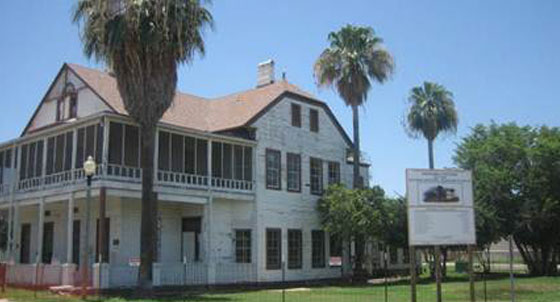
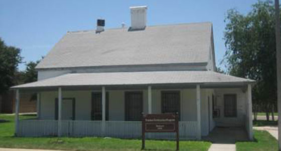
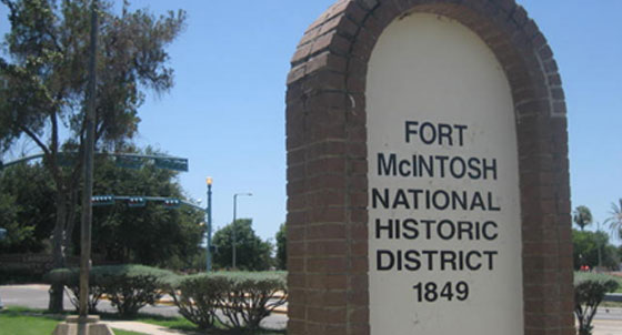
Fort McIntosh was established in a big bend of the Rio Grande less than a mile above Laredo on March 3, 1849, just below a favorite Indian crossing on the river called Paso de los Indios. Originally named Camp Crawford, it was later renamed in honor of Lieutenant Colonel James Simmons McIntosh who died of wounds received during the U.S.-Mexican War. Of the nineteen men who commanded the isolated post in the years prior to the Civil War, six became generals in the Union army and three obtained the rank of general in the Confederacy such as Philip H. Sheridan, Randolph B. Marcy and James E. Slaughter. With the secession of Texas in 1861, the small garrison of federal troops departed Laredo, and Charles Callahan, agent for the state of Texas, took possession of the post. Shortly thereafter, it was turned over to Col. Santos Benavides, who established his headquarters there. However, early in the war, most of the buildings were sold by town authorities and by 1865, there was little left of the original post. When the U.S. Army, including U.S. Colored Troops, reoccupied the property in 1865, Fort McIntosh was rebuilt and continued as one of the major posts on the Rio Grande. It was officially abandoned after World War II. The property was turned over to the local school district, which established a community college on the site. Many of the buildings, including one of the barracks dating to the 1880s, can be seen at Laredo Community College today.
Listen
Fundado en un amplio meandro del Río Grande el 3 de marzo de 1849, apenas una milla por encima de Laredo, el Fuerte McIntosh se levanta justo bajo uno de los pasos del río más usado por los nativos, conocido como «Paso de los Indios». Se estableció bajo el nombre de Camp Crawford, y con posterioridad se renombró en honor del teniente coronel James Simmons McIntosh, quien falleciera a causa de las heridas recibidas durante la guerra entre México y Estados Unidos, la Guerra de Intervención. Seis de los diecinueve hombres que estuvieron al mando de este emplazamiento durante los años que precedieron a la Guerra de Secesión estadounidense alcanzaron el rango de general en el ejército de la Unión, y tres de ellos en la Confederación, como Philip H. Sheridan, Randolph B. Marcy and James E. Slaughter. Con la secesión de Texas en 1861, la pequeña guarnición de federales abandonó Laredo y, Charles Callahan, en nombre del Estado de Texas, tomó posesión del puesto. Poco después, el mando fue entregado al capitán confederado y futuro coronel Santos Benavides, quien estableció aquí su cuartel general, pero en los primeros compases de la guerra, la mayor parte de los edificios fueron vendidos por las autoridades locales, y hacia 1865 apenas quedaba nada del fuerte original. Cuando el ejército de los Estados Unidos, incluyendo el Regimiento Negro, volvió a ocupar los terrenos en 1865, se reconstruyó el Fuerte McIntosh, continuando su función como uno de los puestos fronterizos de mayor importancia en el Río Grande. Se abandonó oficialmente después de la Segunda Guerra Mundial: el lugar fue cedido al distrito escolar local y allí se fundó una escuela universitaria. Muchos de los edificios, incluyendo unos barracones que se remontan a la década de 1880, pueden aún verse en la actualidad en el Colegio Universitario de Laredo.
Escucha
Details
Location: Grounds of Laredo Community College, West End Washington St., Laredo Texas.
GPS Coordinates
Photos
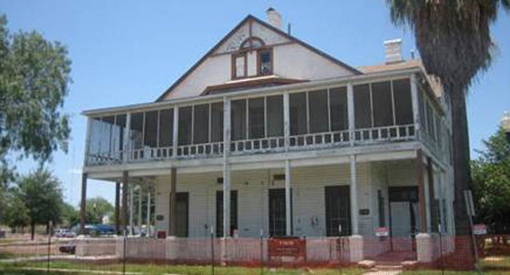
Fort McIntosh