skip to main content
UTRGV The University of Texas Rio Grande Valley
Main Menu
Donate Now Directory myUTRGV

You are here:

Civil War Trail Cameron County Sheridan Bridge

Rio Grande Valley Civil War Trail College of Liberal Arts

  • Home
  • About Us
    • Project Brief
    • Faculty & Staff
    • Project Scholars & Editors
    • Lead Advisor by County
    • Contributors and Committee
    • Community Engagement
    • Undergraduate & Graduate Assistants
  • Civil War Trail
    • Cameron County
      • Bagdad
      • Brazos Island
      • Brownsville during the Civil War
      • Clarksville
      • Fort Brown
      • Las Rucias
      • Neale House
      • Old City Cemetery
      • Palmito Ranch
      • Palo Alto Battlefield
      • Point Isabel
      • Rio Grande
      • Sheridan Bridge
      • Stillman House
    • Hidalgo County
      • City of Hidalgo (Original Edinburgh)
      • Havana
      • Jackson Ranch
      • La Bolsa Blend
      • McAllen Ranch
      • Museum of South Texas History
      • Peñitas Cemetery
      • Webber's Ranch
      • La Sal del Rey
    • Imperial Mexico
      • Benito Juarez
      • Matamoros
      • Mexico from 1846 to 1876
      • Mexico and the U.S. Civil War
      • Porfirio Díaz
      • The Franco-Austrian Invasion
    • Jim Wells County
      • Battle at Los Patricios
    • Kleberg County
      • King Ranch
    • Starr County
      • John Vale/Noah Cox House
      • Juan Cortina
      • Mifflin Kenedy Warehouse
      • Old Rio Grande Cemetery
      • Ramirez Hospital
      • Ringgold Barracks
      • Robert E. Lee House
      • Roma Historic District
    • Webb County
      • Col. Santos Benavides
      • Fort McIntosh
      • St. Augustine Plaza, Laredo
      • Zacate Creek
    • Zapata County
      • Confederate Retaliation at La Soledad
      • Confrontation at Carrizo
      • Massacre at El Clareño
      • Reconstruction Era in Zapata County
      • Second Battle of El Clareño and Hanging of Zapata County Judge
      • Skirmish at Redmond's Ranch
    • U.S. Colored Troops
    • Cortina and the First war
    • Cortina and the “Second Cortina War”
    • Juan Nepomuceno Cortina and the American Civil War
  • Press
  • Academic Resources
    • Audio Tours
      • Cameron County
      • Hidalgo County
      • Imperial Mexico
      • Kennedy County
      • Starr County
      • Webb County
      • Zapata County
    • Audio Español
      • Cameron County
      • Hidalgo County
      • Imperial Mexico
      • Kennedy County
      • Starr County
      • Webb County
      • Zapata County
    • References
    • Kid's Corner
    • Teaching Tools
      • TEKS-Aligned Lesson Plans
      • Traveling Trunk Posters
    • Published Books
    • Girl Scouts of Greater South Texas
    • Documentary Films
    • Radio Interviews
    • Recorded Presentations
  • Attractions
  • Partners
  • Donate

Cameron County - Related Links

  • Bagdad
  • Brazos Island
  • Brownsville during the Civil War
  • Clarksville
  • Fort Brown
  • Las Rucias
  • Neale House
  • Old City Cemetery
  • Palmito Ranch
  • Palo Alto Battlefield
  • Point Isabel
  • Rio Grande
  • Sheridan Bridge
  • Stillman House

Contact Us

RGV- Civil War Program
The University of Texas Rio Grande Valley
1201 W. University Dr.
LAMR 1.103
Conference Room LAMR 1.104
Email: chaps@utrgv.edu
Phone: (956) 665-3231

Quick Links

CHAPS RGV Civil War “Cotton Times” Film Discovery Trails Sponsorship Opportunities Blue and Gray on the Border: The Rio Grande Valley Civil War Trail The Civil War on the Rio Grande, 1846–1876

Sheridan Bridge

  • English
  • Español

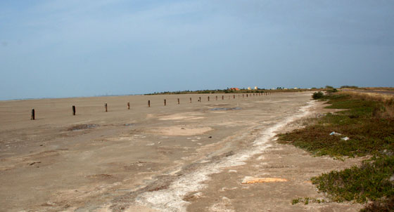
The line of palmetto pilings just to the north of Highway 4 at Boca Chica Beach are the remains of a Union railroad built at the close of the Civil War. These posts were the foundations of a bridge that crossed the narrow Boca Chica inlet to connect Brazos Island to the mainland at White’s Ranch. When Union troops entered the Rio Grande delta in November 1863, they landed on Brazos Island and crossed the Boca Chica waterway using temporary floating pontoon bridges. After occupying Brownsville, Union General Francis Herron gave orders to build a railway and bridge that would transport troops and supplies to river steamboats which would carry them to points upriver. Union troops fell back to Brazos Island in spring 1864, scrapping plans for the line. When the Confederacy collapsed in May 1865 and Union forces re-entered Brownsville, the line again became a priority. General Philip Sheridan, commander of the Union Military Division of the Southwest, feared that Confederates who had fled to Mexico might stage attacks from across the border, perhaps in alliance with Mexican imperialist forces. Consequently he ordered completion of the railroad and bridge, which was constructed by U.S. Colored Troops. The line was a short lived one, however: the hurricane of 1867, which wiped out the towns of Bagdad, Clarksville, and the Brazos Santiago depot, also destroyed Sheridan's bridge.
It was never rebuilt.

Listen


La línea de pilotes de troncos de palma justo al norte de la carretera número 4 en la playa de Boca Chica son los restos de una vía férrea de la Unión construida hacia el final de la Guerra de Secesión estadounidense. Se trataba de las columnas que sostenían el puente a través del estrecho brazo de mar de Boca Chica para conectar la Isla de Brazos con la tierra firme en el Rancho White. Cuando las fuerzas unionistas entraron en el delta del Río Grande en noviembre de 1863, desembarcaron en dicha isla y salvaron el paso sobre las aguas utilizando un puente provisional de pontones flotantes. Después de ocupar Brownsville, el general unionista Francis Herron ordenó construir una vía férrea y un puente para acarrear tropas y suministros hasta los vapores que, a su vez, los transportarían río arriba. El posterior repliegue unionista hasta la Isla de Brazos en la primavera de 1864 desbarató estos planes aunque, cuando la Confederación se desmoronó en mayo de 1865 y las fuerzas unionistas reconquistaron Brownsville, el trazado de la vía férrea volvió a ser prioritario. El General Philip Sheridan, comandante en jefe de la División del Suroeste de las Fuerzas Armadas de la Unión, recelaba de que los confederados huidos a México pudieran plantar batalla cruzando la frontera, quizás aliados con las fuerzas imperialistas mexicanas, así que ordenó la finalización de la vía y del puente, que fueron construidos por el Regimiento Negro de los EE.UU. Pero el trazado tuvo una corta vida, pues el huracán de 1867, que arrasó las localidades de Bagdad, Clarksville, así como el polvorín de Brazos Santiago, también destruyó el puente de Sheridan, que no volvió a ser reconstruido.

Escucha


Details

Location: Boca Chica and end of HWY 4

GPS Coordinates

Photos

Sheridan Bridge
Sheridan Bridge
Jump to Top
Give to UTRGV

UTRGV

  • Twitter
  • Facebook
  • LinkedIn
  • YouTube
  • CARES, CRRSAA and ARP Reporting
  • Site Policies
  • Contact UTRGV
  • Required Links
  • Fraud Reporting
  • Senate Bill 18 Reporting
  • UTRGV Careers
  • Clery Act Reports
  • Web Accessibility
  • Mental Health Resources
  • Sexual Misconduct Policy
  • Reporting Sexual Misconduct