skip to main content
UTRGV The University of Texas Rio Grande Valley
Main Menu
Donate Now Directory myUTRGV

You are here:

Civil War Trail Cameron County Clarksville

Rio Grande Valley Civil War Trail College of Liberal Arts

  • Home
  • About Us
    • Project Brief
    • Faculty & Staff
    • Project Scholars & Editors
    • Lead Advisor by County
    • Contributors and Committee
    • Community Engagement
    • Undergraduate & Graduate Assistants
  • Civil War Trail
    • Cameron County
      • Bagdad
      • Brazos Island
      • Brownsville during the Civil War
      • Clarksville
      • Fort Brown
      • Las Rucias
      • Neale House
      • Old City Cemetery
      • Palmito Ranch
      • Palo Alto Battlefield
      • Point Isabel
      • Rio Grande
      • Sheridan Bridge
      • Stillman House
    • Hidalgo County
      • City of Hidalgo (Original Edinburgh)
      • Havana
      • Jackson Ranch
      • La Bolsa Blend
      • McAllen Ranch
      • Museum of South Texas History
      • Peñitas Cemetery
      • Webber's Ranch
      • La Sal del Rey
    • Imperial Mexico
      • Benito Juarez
      • Matamoros
      • Mexico from 1846 to 1876
      • Mexico and the U.S. Civil War
      • Porfirio Díaz
      • The Franco-Austrian Invasion
    • Jim Wells County
      • Battle at Los Patricios
    • Kleberg County
      • King Ranch
    • Starr County
      • John Vale/Noah Cox House
      • Juan Cortina
      • Mifflin Kenedy Warehouse
      • Old Rio Grande Cemetery
      • Ramirez Hospital
      • Ringgold Barracks
      • Robert E. Lee House
      • Roma Historic District
    • Webb County
      • Col. Santos Benavides
      • Fort McIntosh
      • St. Augustine Plaza, Laredo
      • Zacate Creek
    • Zapata County
      • Confederate Retaliation at La Soledad
      • Confrontation at Carrizo
      • Massacre at El Clareño
      • Reconstruction Era in Zapata County
      • Second Battle of El Clareño and Hanging of Zapata County Judge
      • Skirmish at Redmond's Ranch
    • U.S. Colored Troops
    • Cortina and the First war
    • Cortina and the “Second Cortina War”
    • Juan Nepomuceno Cortina and the American Civil War
  • Press
  • Academic Resources
    • Audio Tours
      • Cameron County
      • Hidalgo County
      • Imperial Mexico
      • Kennedy County
      • Starr County
      • Webb County
      • Zapata County
    • Audio Español
      • Cameron County
      • Hidalgo County
      • Imperial Mexico
      • Kennedy County
      • Starr County
      • Webb County
      • Zapata County
    • References
    • Kid's Corner
    • Teaching Tools
      • TEKS-Aligned Lesson Plans
      • Traveling Trunk Posters
    • Published Books
    • Girl Scouts of Greater South Texas
    • Documentary Films
    • Radio Interviews
    • Recorded Presentations
  • Attractions
  • Partners
  • Donate

Cameron County - Related Links

  • Bagdad
  • Brazos Island
  • Brownsville during the Civil War
  • Clarksville
  • Fort Brown
  • Las Rucias
  • Neale House
  • Old City Cemetery
  • Palmito Ranch
  • Palo Alto Battlefield
  • Point Isabel
  • Rio Grande
  • Sheridan Bridge
  • Stillman House

Contact Us

RGV- Civil War Program
The University of Texas Rio Grande Valley
1201 W. University Dr.
LAMR 1.103
Conference Room LAMR 1.104
Email: chaps@utrgv.edu
Phone: (956) 665-3231

Quick Links

CHAPS RGV Civil War “Cotton Times” Film Discovery Trails Sponsorship Opportunities Blue and Gray on the Border: The Rio Grande Valley Civil War Trail The Civil War on the Rio Grande, 1846–1876

Clarksville

  • English
  • Español

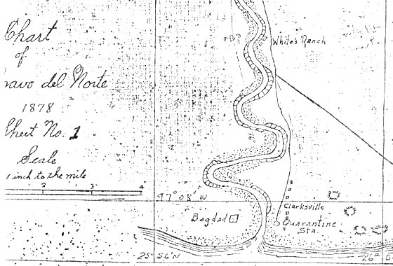
Clarksville was a small community located near the northern edge of the mouth of the Rio Grande opposite Bagdad. Founded during the 1840s, Clarksville served as a staging area for U.S. troops during the Mexican American War. Early in the Civil War, Clarksville prospered because of the cotton trade and presence of Confederate blockade-runners. In 1863, however, the area was captured and occupied by Union forces, which seized private homes and warehouses and caused most residents to flee. As part of emperor Maximilian’s efforts to suppress Mexican resistance, French gunboats occasionally shelled Clarksville. Theresa Clark Clearwater, daughter of the town's founder, recalled that "often the families were forced to take refuge behind some big sand hill during these bombardments." Troops of the Texas Confederate Calvary, as well as French and Austrian soldiers from Maximilian’s forces also frequented Clarksville. In 1866, American filibusters, private soldiers of fortune, attacked Maximilian's imperial forces at neighboring Bagdad with the help of black soldiers from the 118th U.S. Colored Infantry. The great hurricane of 1867 killed many residents and caused heavy damage to Clarksville, but the community survived. In 1872, the building of a railway from Brownsville to Port Isabel diverted commerce away from Clarksville, which was damaged again by storms in 1874 and 1886. Eventually, the little community ceased to exist, and a change in the course of the Rio Grande in 1953 resulted in the river flowing over the old site.

Listen


Esta pequeña comunidad se localizaba cerca del extremo septentrional de la desembocadura del Río Grande, frente a la ciudad de Bagdad. Fundada en la década de 1840, Clarksville sirvió como zona de tránsito para las tropas estadounidenses durante la Guerra Méxicoestadounidense o Guerra de Intervención. A principios de la Guerra de Secesión, el comercio de algodón y la presencia de contrabandistas confederados que burlaban el bloqueo hizo prosperar la localidad, pero en 1863 la zona fue tomada y ocupada por las fuerzas unionistas, que confiscaron viviendas privadas y almacenes, haciendo que la mayor parte de los residentes se dieran a la fuga. Como parte de los esfuerzos del emperador Maximiliano por suprimir la resistencia mexicana, cañoneras francesas bombardeaban ocasionalmente el pueblo. Theresa Clark Clearwater, hija del fundador del mismo, recodaba cómo «las familias se veían obligadas con frecuencia a buscar resguardo detrás de una duna grande durante aquellos cañoneos». Las fuerzas de la Caballería Confederada de Texas, así como soldados franceses y austriacos de las fuerzas de Maximiliano, también frecuentaban el lugar. En 1866, filibusteros estadounidenses, mercenarios y soldados de fortuna, atacaron a las tropas imperiales en la vecina localidad de Bagdad, con la ayuda del 118 Regimiento Negro de Infantería del Ejército de los Estados Unidos. El gran huracán de 1867 acabó con las vidas de muchos de los residentes y causó grandes pérdidas en Clarksville, pero la comunidad sobrevivió. En 1872, no obstante, la construcción de una línea de ferrocarril entre Brownsville y Puerto Isabel desvió el flujo comercial apartándolo de Clarksville, que fue castigado de nuevo por las tormentas de 1874 y 1886. En último término, la pequeña comunidad dejó de existir, y un cambio en el curso del Río Grande en 1953 causó la inundación permanente del antiguo emplazamiento.

Escucha


Details

Location:  Small community located near the mouth of the Rio Grande River opposite Bagdad. A change in the course of the Rio Grande River in 1953 resulted in the river flowing over the old site.

GPS Coordinates

Photos

Clarksville map location
Courtesy of the McCaleb Files at
The University of Texas Rio Grande
Valley, Special Collections Library
Jump to Top
Give to UTRGV

UTRGV

  • Twitter
  • Facebook
  • LinkedIn
  • YouTube
  • CARES, CRRSAA and ARP Reporting
  • Site Policies
  • Contact UTRGV
  • Required Links
  • Fraud Reporting
  • Senate Bill 18 Reporting
  • UTRGV Careers
  • Clery Act Reports
  • Web Accessibility
  • Mental Health Resources
  • Sexual Misconduct Policy
  • Reporting Sexual Misconduct