skip to main content
UTRGV The University of Texas Rio Grande Valley
Main Menu
Donate Now Directory myUTRGV

You are here:

Civil War Trail Cameron County Rio Grande

Rio Grande Valley Civil War Trail College of Liberal Arts

  • Home
  • About Us
    • Project Brief
    • Faculty & Staff
    • Project Scholars & Editors
    • Lead Advisor by County
    • Contributors and Committee
    • Community Engagement
    • Undergraduate & Graduate Assistants
  • Civil War Trail
    • Cameron County
      • Bagdad
      • Brazos Island
      • Brownsville during the Civil War
      • Clarksville
      • Fort Brown
      • Las Rucias
      • Neale House
      • Old City Cemetery
      • Palmito Ranch
      • Palo Alto Battlefield
      • Point Isabel
      • Rio Grande
      • Sheridan Bridge
      • Stillman House
    • Hidalgo County
      • City of Hidalgo (Original Edinburgh)
      • Havana
      • Jackson Ranch
      • La Bolsa Blend
      • McAllen Ranch
      • Museum of South Texas History
      • Peñitas Cemetery
      • Webber's Ranch
      • La Sal del Rey
    • Imperial Mexico
      • Benito Juarez
      • Matamoros
      • Mexico from 1846 to 1876
      • Mexico and the U.S. Civil War
      • Porfirio Díaz
      • The Franco-Austrian Invasion
    • Jim Wells County
      • Battle at Los Patricios
    • Kleberg County
      • King Ranch
    • Starr County
      • John Vale/Noah Cox House
      • Juan Cortina
      • Mifflin Kenedy Warehouse
      • Old Rio Grande Cemetery
      • Ramirez Hospital
      • Ringgold Barracks
      • Robert E. Lee House
      • Roma Historic District
    • Webb County
      • Col. Santos Benavides
      • Fort McIntosh
      • St. Augustine Plaza, Laredo
      • Zacate Creek
    • Zapata County
      • Confederate Retaliation at La Soledad
      • Confrontation at Carrizo
      • Massacre at El Clareño
      • Reconstruction Era in Zapata County
      • Second Battle of El Clareño and Hanging of Zapata County Judge
      • Skirmish at Redmond's Ranch
    • U.S. Colored Troops
    • Cortina and the First war
    • Cortina and the “Second Cortina War”
    • Juan Nepomuceno Cortina and the American Civil War
  • Press
  • Academic Resources
    • Audio Tours
      • Cameron County
      • Hidalgo County
      • Imperial Mexico
      • Kennedy County
      • Starr County
      • Webb County
      • Zapata County
    • Audio Español
      • Cameron County
      • Hidalgo County
      • Imperial Mexico
      • Kennedy County
      • Starr County
      • Webb County
      • Zapata County
    • References
    • Kid's Corner
    • Teaching Tools
      • TEKS-Aligned Lesson Plans
      • Traveling Trunk Posters
    • Published Books
    • Girl Scouts of Greater South Texas
    • Documentary Films
    • Radio Interviews
    • Recorded Presentations
  • Attractions
  • Partners
  • Donate

Cameron County - Related Links

  • Bagdad
  • Brazos Island
  • Brownsville during the Civil War
  • Clarksville
  • Fort Brown
  • Las Rucias
  • Neale House
  • Old City Cemetery
  • Palmito Ranch
  • Palo Alto Battlefield
  • Point Isabel
  • Rio Grande
  • Sheridan Bridge
  • Stillman House

Contact Us

RGV- Civil War Program
The University of Texas Rio Grande Valley
1201 W. University Dr.
LAMR 1.103
Conference Room LAMR 1.104
Email: chaps@utrgv.edu
Phone: (956) 665-3231

Quick Links

CHAPS RGV Civil War “Cotton Times” Film Discovery Trails Sponsorship Opportunities Blue and Gray on the Border: The Rio Grande Valley Civil War Trail The Civil War on the Rio Grande, 1846–1876

Rio Grande

  • English
  • Español

It is not surprising that the Rio Grande itself played a central role in the history of the Civil War in the Rio Grande Valley. As Federal blockades sealed off the Confederate coastline, Mexico became a vital outlet for southerners to export their cotton. But the river's significance dates back much earlier. In the 1848 Treaty of Guadalupe Hidalgo, the United States and Mexico agreed that the waterway which divided their two nations would be an international river, open to merchants of both countries. In the 1860s, this agreement prohibited the Union Navy from halting shipments along the river. Merchants brought their cotton to Matamoros, loaded it on Mexican-registered steamboats, and transported it to Bagdad where it was transferred to larger ships for international distribution. Union forces could not halt this flow of supplies without widening the war's scope to Mexico, which was itself beset at that time by civil war. Although the U.S. Army did briefly occupy towns of the Rio Grande Valley and slowed the flow of cotton southward, boats filled with cotton continued to ply the river's waters, unimpeded for the duration of the war.

Listen


No resulta sorprendente que el Río Grande en sí mismo desempeñara un papel crucial en el desarrollo histórico de la Guerra de Secesión de Estados Unidos en El Valle: según los bloqueos federales aislaban la línea costera confederada, México se convirtió en una salida vital para las exportaciones algodoneras de los sureños. Pero la importancia del río se remonta a mucho antes: en 1848, en virtud del Tratado de Guadalupe Hidalgo, los Estados Unidos y México acordaron que esta vía fluvial divisora de ambas naciones se constituiría en aguas internacionales, abiertas al comercio de ambos países. En la década de 1860, este compromiso impedía que la Armada de la Unión interceptara las mercancías despachadas por el río, con lo que los comerciantes llevaban el algodón hasta Matamoros, lo embarcaban en vapores fletados bajo bandera mexicana hasta Bagdad, donde se transbordaba a embarcaciones de mayor calado para su distribución internacional. Las tropas unionistas no podían detener este flujo de suministros sin expandir el alcance de la guerra hasta México, que se encontraba a su vez en ese momento sumido en una guerra civil. Si bien el ejército de los EE. UU. ocupó brevemente algunas poblaciones de El Valle del Río Grande, aminorando así el tráfico de algodón dirigido hacia el sur, las aguas del río siguieron siendo surcadas con libertad hasta el final de la contienda por embarcaciones cargadas de esta fibra.

Escucha


Details

Location: Below El Paso, the Rio Grande serves as part of the border between the United States and Mexico.

Access: Not available for public access.

GPS Coordinates

Photos

Pontoon Bridge
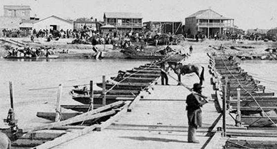
Pontoon Bridge over Rio Grande between
Brownsville and Matamoros c.1866 -
Print courtesy Institute of Texas Cultures,
University of Texas at Brownsville, 73-833.
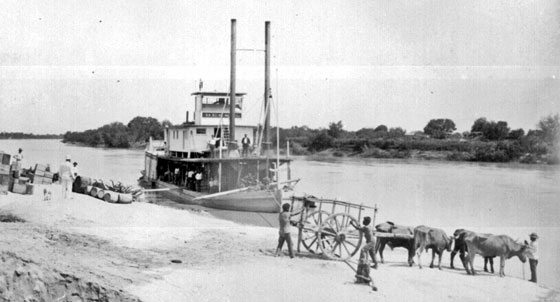
Steamboat at Ringgold Barracks
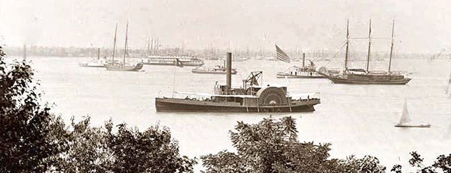
Civil War Transport
Civil War Transport
Jump to Top
Give to UTRGV

UTRGV

  • Twitter
  • Facebook
  • LinkedIn
  • YouTube
  • CARES, CRRSAA and ARP Reporting
  • Site Policies
  • Contact UTRGV
  • Required Links
  • Fraud Reporting
  • Senate Bill 18 Reporting
  • UTRGV Careers
  • Clery Act Reports
  • Web Accessibility
  • Mental Health Resources
  • Sexual Misconduct Policy
  • Reporting Sexual Misconduct