skip to main content
UTRGV The University of Texas Rio Grande Valley
Main Menu
Donate Now Directory myUTRGV

You are here:

Civil War Trail Hidalgo County Jackson Ranch

Rio Grande Valley Civil War Trail College of Liberal Arts

  • Home
  • About Us
    • Project Brief
    • Faculty & Staff
    • Project Scholars & Editors
    • Lead Advisor by County
    • Contributors and Committee
    • Community Engagement
    • Undergraduate & Graduate Assistants
  • Civil War Trail
    • Cameron County
      • Bagdad
      • Brazos Island
      • Brownsville during the Civil War
      • Clarksville
      • Fort Brown
      • Las Rucias
      • Neale House
      • Old City Cemetery
      • Palmito Ranch
      • Palo Alto Battlefield
      • Point Isabel
      • Rio Grande
      • Sheridan Bridge
      • Stillman House
    • Hidalgo County
      • City of Hidalgo (Original Edinburgh)
      • Havana
      • Jackson Ranch
      • La Bolsa Blend
      • McAllen Ranch
      • Museum of South Texas History
      • Peñitas Cemetery
      • Webber's Ranch
      • La Sal del Rey
    • Imperial Mexico
      • Benito Juarez
      • Matamoros
      • Mexico from 1846 to 1876
      • Mexico and the U.S. Civil War
      • Porfirio Díaz
      • The Franco-Austrian Invasion
    • Jim Wells County
      • Battle at Los Patricios
    • Kleberg County
      • King Ranch
    • Starr County
      • John Vale/Noah Cox House
      • Juan Cortina
      • Mifflin Kenedy Warehouse
      • Old Rio Grande Cemetery
      • Ramirez Hospital
      • Ringgold Barracks
      • Robert E. Lee House
      • Roma Historic District
    • Webb County
      • Col. Santos Benavides
      • Fort McIntosh
      • St. Augustine Plaza, Laredo
      • Zacate Creek
    • Zapata County
      • Confederate Retaliation at La Soledad
      • Confrontation at Carrizo
      • Massacre at El Clareño
      • Reconstruction Era in Zapata County
      • Second Battle of El Clareño and Hanging of Zapata County Judge
      • Skirmish at Redmond's Ranch
    • U.S. Colored Troops
    • Cortina and the First war
    • Cortina and the “Second Cortina War”
    • Juan Nepomuceno Cortina and the American Civil War
  • Press
  • Academic Resources
    • Audio Tours
      • Cameron County
      • Hidalgo County
      • Imperial Mexico
      • Kennedy County
      • Starr County
      • Webb County
      • Zapata County
    • Audio Español
      • Cameron County
      • Hidalgo County
      • Imperial Mexico
      • Kennedy County
      • Starr County
      • Webb County
      • Zapata County
    • References
    • Kid's Corner
    • Teaching Tools
      • TEKS-Aligned Lesson Plans
      • Traveling Trunk Posters
    • Published Books
    • Girl Scouts of Greater South Texas
    • Documentary Films
    • Radio Interviews
    • Recorded Presentations
  • Attractions
  • Partners
  • Donate

Hidalgo County - Related Links

  • City of Hidalgo (Original Edinburgh)
  • Havana
  • Jackson Ranch
  • La Bolsa Blend
  • McAllen Ranch
  • Museum of South Texas History
  • Peñitas Cemetery
  • Webber's Ranch
  • La Sal del Rey

Contact Us

RGV- Civil War Program
The University of Texas Rio Grande Valley
1201 W. University Dr.
LAMR 1.103
Conference Room LAMR 1.104
Email: chaps@utrgv.edu
Phone: (956) 665-3231

Quick Links

CHAPS RGV Civil War “Cotton Times” Film Discovery Trails Sponsorship Opportunities Blue and Gray on the Border: The Rio Grande Valley Civil War Trail The Civil War on the Rio Grande, 1846–1876

Jackson Ranch

  • English
  • Español

Along the Rio Grande in Hidalgo County lay the Jackson Ranch and Eli Jackson Cemetery, once owned by Nathaniel Jackson, a loyal Unionist during the Civil War. In the 1850’s, Jackson left Alabama with his African-American wife Matilda Hicks, his son Eli, and other adult children. They hoped to escape the intolerance of inter-racial marriage they had known in the South. Accompanying the Jacksons were eleven African-American freedmen. In 1857, Jackson founded his ranch on a former Spanish grant. His property is said to have become a refuge for runaway slaves from Texas and the Deep South. Today, many people know about the Underground Railroad that shepherded enslaved people to freedom in the northern states and Canada, but few know about the route to freedom in Mexico. The Jackson Ranch lay near the Military Highway between Fort Ringgold and Fort Brown, and would have been visited by Confederate and Union troops as they fought for control of the Lower Valley in 1863 and 1864. Jackson died in 1865, the same year that his son Eli established the family cemetery where members of the clan now rest. Nathaniel Jackson’s grave is unmarked.

Listen


Este rancho, junto con el Cementerio Eli Jackson, se extiende en la riba del Río Grande, y fue propiedad de Nathaniel Jackson, quien se mantuviera leal a la causa unionista durante la Guerra de Secesión estadounidense. En la década de 1850, Jackson abandonó Alabama en compañía de su esposa afroamericana Matilda Hicks y su hijo Eli, así como de otros hijos ya adultos, esperando escapar de la intolerancia contra los matrimonios interraciales que habían tenido que soportar en el sur de los EE.UU. Les acompañaban también once afroamericanos liberados, y en 1857 Jackson estableció su rancho en terrenos de una antigua concesión española. Se dice que la propiedad se convirtió en refugio de esclavos huidos, venidos desde otros lugares de Texas y del sur profundo. En la actualidad, mucha gente ha oído hablar del tren subterráneo que acarreaba esclavos hacia la libertad en los estados norteños del país y al Canadá, pero pocos saben de la ruta hacia la libertad que existía en dirección a México. El Rancho Jackson se encontraba cerca de una carretera militar que unía el Fuerte Ringgold con el Fuerte Brown, y fue visitado por tropas tanto confederadas como unionistas durante su lucha por controlar el bajo Valle del Río Grande en 1863 y 1864. Jackson falleció en 1865, el mismo año en que su hijo Eli estableció el cementerio familiar donde los restos mortales de sus familiares ahora descansan. Nathaniel Jackson yace en una tumba sin identificar.

Escucha


Details

Location: (From Cemeteries of Texas): Drive south of Pharr on U.S. 281 to Fay’s Corners, where 281 turns east. Stay on 281 and go east .8 mile, then turn south and cross the canal levee; go .4 mile, turn east toward church spire .2 mile. Cemetery is 500 feet northeast of the church, against the canal embankment.

Access: No known restrictions at this time.

GPS Coordinates

Photos

Martin Jackson Headstone
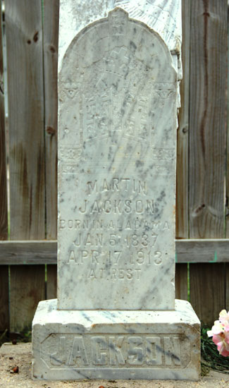
Martin Jackson - Headstone
Jackson Cementery
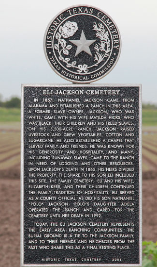
Eli Jackson Cemetery Texas Historical Marker
Jackson Ranch church
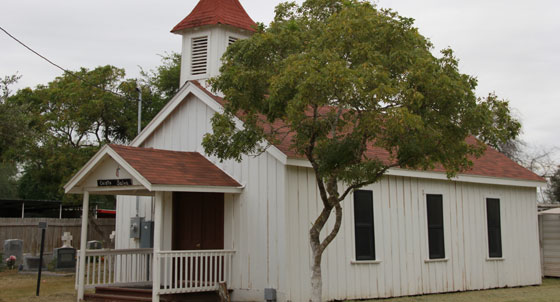
Jackson Ranch Church and Cemetery
Jump to Top
Give to UTRGV

UTRGV

  • Twitter
  • Facebook
  • LinkedIn
  • YouTube
  • CARES, CRRSAA and ARP Reporting
  • Site Policies
  • Contact UTRGV
  • Required Links
  • Fraud Reporting
  • Senate Bill 18 Reporting
  • UTRGV Careers
  • Clery Act Reports
  • Web Accessibility
  • Mental Health Resources
  • Sexual Misconduct Policy
  • Reporting Sexual Misconduct