The Goliad Rock Formation lies atop the Catahoula and extends east towards Ramondville. It is visible at an abandoned Caliche gravel pit, just east of the Ash outcrops. 19th century farmers built hand dug wells through the permeable sands and gravel of the Goliad and adjacent South Texas Sand Sheet.
Water wells, or norias, were excavated by rancheros in the early nineteenth century to make cattle ranching possible in vast expanses of land which lacked flowing water. Guided by the presence of trees with long roots that reach the deeply buried water table, the rancheros dug their wells where these trees thrived and found fresh water.
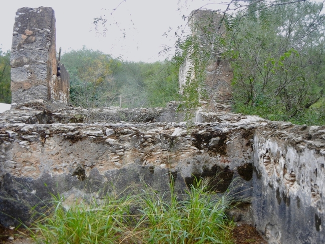
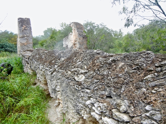
Remnants of some of these norias are found today in northern Hidalgo and Starr counties. There the wells were excavated to depths of 9 meters (30 feet) through a thick layer of caliche, a sedimentary rock comprised of calcium carbonate found in arid and semi-arid regions. Specially designed features of some of these norias included a pulley structure, an above-ground storage tank built adjacent to the well shaft, and a water trough connected to the storage tank that served to supply drinking water to herds of cattle. These were built with the caliche quarried from the well shaft and covered with a finish of lime plaster. Mesquite timber was used for the pulley, and water was hoisted with rawhide buckets capable of removing 60 to 80 liters (15 to 20 gallons) of water at a time.
Without the extraction of subterranean water, the land north and south of the Rio Grande in south Texas and northern Tamaulipas would have been unsuitable for occupation by Mexican and later American ranchers.
The noria in San Isidro is the largest and best-preserved remaining structure. It is located on Old San Isidro Road, where visitors can appreciate this handiwork of a past era.
Listen to the podcast in English - San Isidro hand-dug water wells / norias
Los rancheros de principios del siglo XIX excavaron estos pozos, o «norias» para posibilitar la ganadería en las amplias extensiones de terreno carentes de aguas superficiales. Tomando como indicio de la presencia de aguas subterráneas la ubicación de árboles de profundas raíces, los rancheros encontraban así agua dulce. En los condados de Hidalgo y Starr se encuentran restos de dichas norias, las cuales llegaban a alcanzar 9 metros de profundidad a través de gruesas capas de caliche. El caliche es una roca sedimentaria compuesta de carbonato de calcio que se da en regiones áridas y semiáridas. Entre las características distintivas de las norias destacaban los horcones para sostener la carrucha o polea, una alberca elevada adyacente, y un abrevadero conectado a la misma para abastecer de agua a los rebaños. Estos elementos se construían con la piedra caliche extraída durante la excavación del pozo, y se remataban con un revoque de cal. La estructura de la carrucha se construía con madera de mesquite y el agua se extraía con baldes de cuero capaces de elevar entre 60 y 80 litros de agua en cada jalón.
Sin la extracción de aguas subterráneas, los terrenos al norte y al sur de El Valle del Río Grande en el Sur de Texas y en la zona septentrional de Tamaulipas no hubieran sido propicios para la explotación ganadera por parte de los rancheros mexicanos y, con posterioridad, los estadounidenses.
La noria de San Isidro es la estructura mayor y mejor conservada en la actualidad. Se ubica en la antigua carretera de San Isidro, donde el visitante podrá apreciar la tecnología artesanal de épocas pretéritas.
Escucha en Español – pozos excavados manualmente en San Isidro