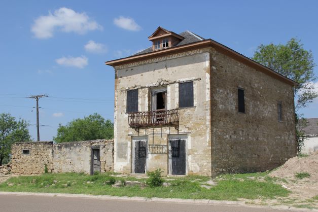
ROMA HISTORIC DISTRICT - John Vale/Noah Cox Home at the City of Roma Historic District
On the western side of the Rio Grande Valley in Roma, we find evidence of a sandy shoreline much like South Padre Island is today. The Roma Sandstone is evidence of its existence. Over the past 43MY, the coastline has prograde over 100 miles east to its current position.
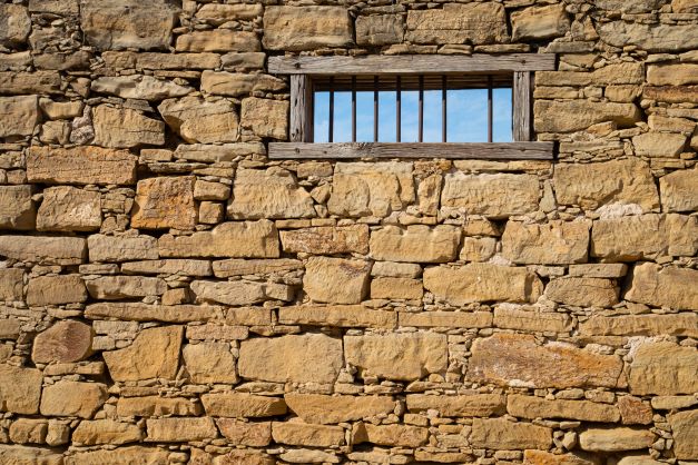
The “Roma Sandstone” is a local informal name for a portion of the Eocene-age Jackson Formation exposed in the cliffs below Water Street in Roma, Texas, and isolated outcrops elsewhere in that region. At the Roma Bluffs, the massively bedded and very resistant sandstone is underlain by thinly bedded layers. These layers are eroding faster in a cut bank of the Rio Grande that runs at the base of the bluffs resulting in undercutting and periodic collapse of large blocks down the nearly vertical cliff face. The bluffs are a World Birding Center site and provide a unique view of a portion of the Mexican border town of Ciudad Miguel Aleman and the international bridge.
The well-cemented and massive Roma sandstone, containing >75% quartz, was used a building material by the first European settlers. Quarried into hand-cut square and rectangular blocks the sandstone was used to build houses including the National Historic Landmark Treviño Fort in San Ygnacio, built in 1830, and the 1853 John Vale/Noah Cox House (above and below), located in Roma’s Historic District.
The John Vale/Noah Cox House, located in Roma’s Historic District, served as both a home and business location for John Heinrik Vale and Noah Cox, who were deeply embroiled in Civil War activities in Roma. Vale, a Swedish immigrant, had come to America in 1840 seeking adventure. During the Mexican American War, Vale volunteered for Zachary Taylor’s Army of Occupation and was encamped in Camargo. He chose to remain in the region, marrying a woman from Ciudad Mier in Tamaulipas and taking up residence across the Rio Grande in Roma. In 1853 he built a two-story home on the town’s main plaza. Three years later he sold the house to Cox, a representative of the New Orleans firm of Stadeker & Mecklinburger & Cox, who continued to use the house as both a residence and mercantile center. In addition to his mercantile operations during the Civil War, Cox also served in the Confederate Texas Cavalry. For his part, Vale engaged heavily in the lucrative cotton trade that funneled through the city of Roma during the Civil War, doing business with Joseph Kleiber, a key player in Confederate business operations on the Gulf of Mexico.
Listen to the English Podcast of Roma Sandstone-The Roma Historic District
Esta porción de la formación eocénica conocida como «Formación Jackson» queda expuesta en los barrancos que se perfilan bajo la calle Water Street, en Roma, Texas, así como en otros afloramientos dispersos en la región. La que se conoce de manera informal por parte de los locales como «Roma Sandstone», es decir, «piedra arenisca de Roma», se observa en los taludes de la localidad, donde los lechos de este resistente mineral se superponen a otros sustratos más finos. Estos últimos, sometidos a la erosión más rápida que les inflige un brazo del Río Grande que discurre al pie del barranco, socavan la base de la formación y causan derrumbes periódicos de grandes bloques que se desploman desde el frente casi vertical de esta quebrada. En este lugar se encuentra también un centro perteneciente al complejo regional de observación ornitológica World Birding Center, y también desde ahí se puede observar una panorámica singular de un sector de la mexicana Ciudad Miguel Alemán, así como su puente fronterizo internacional. La piedra arenisca corresponde a una arenosa playa que se formó hace 43 millones de años cuando la línea costera del Golfo de México discurría por las cercanías de la localidad actual. Así, se trata de las formaciones rocosas más antiguas visibles en El Valle del Bajo Río Grande. De sus canteras se extraían bloques cuadrangulares tallados a mano que se utilizaban para levantar viviendas, como la casa de John Vale y Noah Cox, de 1853. La edificación se encuentra aún en pie en el distrito histórico de esta localidad.
Escucha en Español - roca arenisca de Roma, en el distrito histórico
https://www.utrgv.edu/civilwar-trail/civil-war-trail/starr-county/john-vale-noah-cox/index.htm