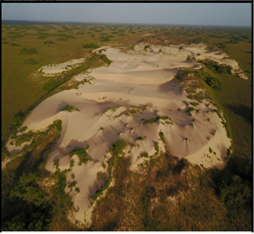
 The South Texas Sand Sheet (STSS) is a ~7,200 km 2 complex of windblown sand deposits located halfway between the Nueces River to the North and the Rio Grande to the south. It spreads over five counties (Kenedy, Brooks, Hidalgo, Jim Hogg and Willacy) from the inland shore of Laguna Madre to 100 km (~62 miles) inland and is considered the most southerly and stabilized dune field in North America. The landscape of the STSS is dominated by a hummocky topography that represents the sand sheet proper.
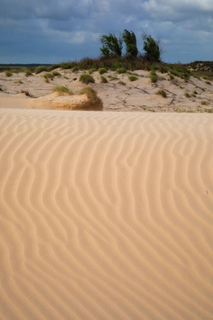
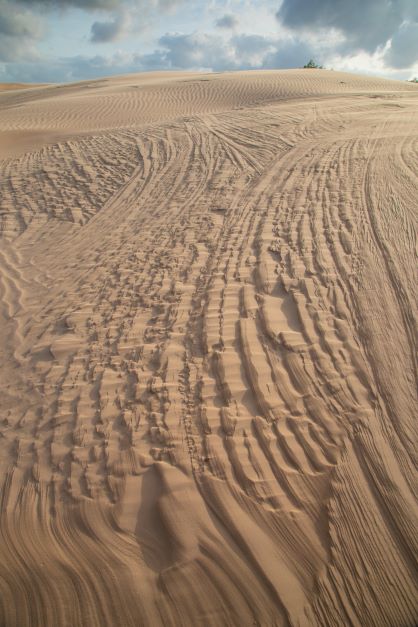
It is stabilized by grassland and discontinuous oak and smaller honey mesquite mottes, with relict and active longitudinal sand dunes oriented to the northwest. Individual active dunes are most common along the inland shore of Laguna Madre where they often reach 1 km² in area, and up to 15 m in elevation.
The area is characterized by limited precipitation (50 cm/yr), high summer temperatures (39 °C), and no flowing water. It sits at the boundary between two floristic kingdoms, the Holarktis of North America and the Neotropis of Central and South America. The unique assemblage of flora in the sand sheet, including 15 species of plants that are endemic to it, is attributed to these and other ecological gradients such as being at the interface of subtropical, coastal, temperate, and desert climate types. The STSS is home to a multitude of native mammals, birds, and reptiles, as well as exotic species, including the largest herd of nilgai in North America, an antelope native to India and Nepal introduced to south Texas in the 1930s, and is intersected by a migratory corridor for monarch butterflies and birds.
The South Texas Sand Sheet, known historically as the Wild Horse Desert, is an approximate2,700 square mile complex of windblown sand deposits located halfway between the Nueces River to the north and the Rio Grande to the south. It spreads over five counties (Kenedy, Brooks, Hidalgo, Jim Hogg and Willacy) from Laguna Madre to 60 miles inland and is considered the most southerly and stabilized dune field in North America. The landscape of the South Texas Sand Sheet is dominated by a hummocky topography that represents the sand sheet proper, stabilized by grassland and discontinuous oak mottes, smaller honey mesquite mottes. These relict and active longitudinal sand dunes oriented to the northwest are under the influence of the southeasterly winds.
The Sand sheet is characterized by limited precipitation (20 inches per year), high summer temperatures (at 102 oF), and no flowing streams or rivers. The unique assemblage of flora in the sand sheet, including 15 species of plants that are endemic to it, is attributed to it being at the interface of subtropical, coastal, temperate, and desert climate types. The South Texas Sand Sheet is home to a multitude of native mammals, birds and reptiles, as well as exotic species, including the largest herd of nilgai, an antelope native of India and Nepal introduced to south Texas in the 1930s, and is intersected by a migratory corridor for butterflies and birds.
The South Texas Sand Sheet formed at the end of Pleistocene Epoch about 10,000 years ago when the Earth’s climate was dryer and windier.
A drive along the 50-mile expanse on US 281 between Linn and Falfurias - or - along US Highway 77 between Raymondville and Sarita, provides a representative view of the South Texas Sand Sheet in its various forms.
Listen to the podcast in English - South Texas Sand Sheet
El Arenal del Sur de Texas, al que se conoce de manera histórica en inglés como «Desierto del Caballo Salvaje», es una extensión de unos 7 000 kilómetros cuadrados de depósitos arenosos transportados por el viento que se encuentra a medio camino entre el Río Nueces, desde el norte, y el Río Grande, desde el sur. Su superficie se extiende por parte de cinco condados (Kenedy, Brooks, Hidalgo, Jim Hogg y Willacy), y desde la Laguna Madre hasta casi cien kilómetros tierra adentro. Se considera el campo de dunas o médanos más meridional y estabilizado de Norteamérica. En el paisaje del Arenal del Sur de Texas predomina una orografía de pequeños montículos, denominados en términos de geomorfología por su nombre en inglés, «hummocks». Los hummocks constituyen el arenal en sí, el cual queda fijado por los pastizales y los manchones discontinuos de encinos y de mezquites dulces, de menor tamaño.
Estas dunas de arena, antiquísimas pero activas, son longitudinales y presentan orientación noroeste a causa de los vientos predominantes del sureste. El arenal está caracterizado por precipitaciones escasas, de 50 litros por metro cuadrado anuales, altas temperaturas estivales cercanas a los 40 grados centígrados, y ausencia de ríos o cursos de agua. Es muy singular el conglomerado de flora del arenal, que incluye 15 especies de plantas endémicas. Este se atribuye al hecho de emplazarse en una zona de transición entre los climas subtropical, litoral, templado y desértico. El Arenal del Sur de Texas alberga multitud de mamíferos, aves y reptiles autóctonos, así como especies exóticas incluyendo el mayor rebaño de toro azul, o nilgó, procedente de la India y Nepal e introducido en el Sur de Texas en 1930. Un corredor migratorio natural de mariposas y aves atraviesa este territorio.
El arenal del Sur de Texas se formó en el Pleistoceno hace unos 10 000 años, durante una época con clima más seco y ventoso en el planeta. Si se recorren en automóvil los 80 kilómetros que unen las poblaciones de Linn y Falfurrias por la carretera nacional 281, o la autopista 77 entre las localidades de Raymondville y Sarita, se apreciarán unas vistas muy representativas de las diversas manifestaciones del Arenal del Sur de Texas.
Escucha en Español – hoja de arena del sur de texas las dunas