Rio Rico
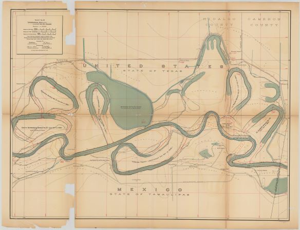
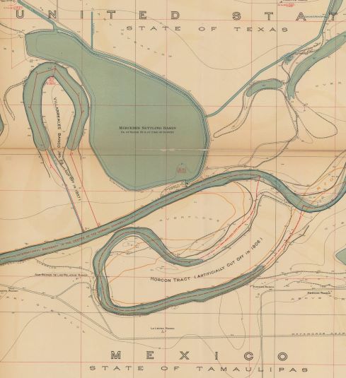
Rio Rico as part of the Horcon Tract - cut off river meander in 1906 when Rio Rico found itself south of the US international border - those born in Rio Rico between 1906 and 1972 were considered US Citizens
Texas State Historical Association https://www.tshaonline.org/handbook/entries/rio-rico-tx
Río Rico, located on the Rio Grande in Hidalgo County, was separated from Texas by a "meander cut" in violation of the treaty between Mexico and the United States. The community was originally located north of the Rio Grande on a narrow finger of land surrounded by an S-shaped curve in the river. In July 1906, however, the American Rio Grande Land and Irrigation Company constructed a cutoff to force the river into a straighter channel. As a result, the 413 acres on which Río Rico is situated came to be located south of the river. The company was eventually taken to court and fined for the diversion of the river, but neither country resolved the issue of territorial rights. The United States never formally relinquished title to the land, since international law dictates that only natural changes of a river's course can transfer territory; over time, however, Río Rico came to be administered by the Mexican government. The issue of territorial rights drew notice once again in 1967, when James Hill, Jr., a geography professor at Arizona State University, rediscovered the shift while studying old geological survey maps. The United States Boundary Commission and the State Department investigated and confirmed Hill's findings, and in 1972 the United States officially ceded the tract of land to the Republic of Mexico. In 1972, however, a resident of Río Rico, Homero Cantú Treviño, filed suit to prevent the United States Immigration and Naturalization Service from deporting him from Texas to Mexico, arguing that he was an American citizen. In 1976 a judge ruled against him; the next year an appeals court ruled that because the 1906 cutoff was unauthorized, anyone born in Río Rico from 1906 to 1972 was entitled to United States citizenship. The Río Rican acreage is known in Mexico as the Horcón tract.
https://www.youtube.com/watch?v=hWSLVL6qbvE
The Río Grande flows through a flood plain and alluvial delta before emptying into the Gulf of Mexico. Land erosion along its banks due to natural river flow and strong storms has forced migration of the river channel throughout the south Texas region. In 1906, the Texas based Rio Grande Land and Irrigation Company dug a diversionary channel as part of its irrigation system. This caused an original “S” curve portion of the tract to detach, causing it to “move” to the Mexican side of the river. This 419-acre tract of land called El Horcón, originally located just south of Mercedes, Texas in Hidalgo County henceforth was abandoned on the Mexican side of the international boundary.
The Mexican town of Río Rico was established near this tract in 1926 and a wooden suspension bridge at Thayer, Texas was built in 1929 to provide access to the town. The United States maintained an international port of entry to accommodate traffic during prohibition; outside investors capitalized on multiple business opportunities and visitors flocked to patronize dog races, restaurants, and speakeasies. The US government never exercised jurisdiction over the Horcón tract and eventually ceded it to Mexico in 1972. Only some of the people who were born within the US portion of Río Rico between 1906 and 1971 have been granted US citizenship. Today, there is little left of the town that stands 3½ miles east of Nuevo Progresso.
Listen to the podcast in English - Rio Rico
El Río Grande discurre por una llanura y un delta aluviales antes de desembocar en el Golfo de México. La erosión del terreno a lo largo de sus márgenes debida al caudal natural del agua y a las fuertes tormentas propicia el desplazamiento lateral del curso del río a lo largo de la región meridional de Texas. En 1906, la corporación texana de regadíos Rio Grande Land and Irrigation Company excavó un brazo artificial del río como parte de su red de canales, lo que provocó que un meandro en forma de letra «S» se desgajara del curso fluvial haciendo que aquél se «desplazara» hacia la margen mexicana del río. Esta bolsa de tierra de casi 170 hectáreas, denominada El Horcón, se encontraba en un principio al sur de la localidad de Mercedes, en el condado de Hidalgo, pero quedó abandonada en el lado mexicano de la frontera internacional.
La población mexicana de Río Rico se fundó cerca de este terreno en 1926, y tres años más tarde se construyó un puente colgante de madera en Thayer, para dar acceso al lugar desde Texas. Durante la época de la Ley Seca, Estados Unidos mantuvo allí un punto de acceso internacional para canalizar el tráfico, mientras muchos inversores de otros lugares capitalizaban las múltiples oportunidades comerciales generadas por quienes acudían a las carreras de perros, restaurantes y salones donde se servía bebidas alcohólicas de manera clandestina. El gobierno de los Estados Unidos nunca ejerció su jurisdicción sobre El Horcón y acabó cediéndoselo a México en 1972. Solo se le concedió la ciudadanía estadounidense a una pequeña parte de las personas nacidas en el sector estadounidense de Río Rico entre 1906 y 1917. En la actualidad queda muy poco del pueblo original ubicado a poco menos de seis kilómetros al este de Nuevo Progreso.


